Trempealeau Mountain from Brady's Bluff (Wisconsin DNR)
|
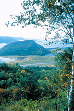
Lookout! — A Sampling of River ViewsBy Pamela Eyden and Reggie McLeod The steep bluffs of the Driftless Region offer almost as many great views as there are twists and turns in the river. Autumn paints the wooded bluffs crimson and gold, and the river mirrors the flashy display. This sampling includes views from Red Wing, Minnesota, to Cassville, Wisconsin. Most of the sites are accessible by car, but three require a brisk uphill hike. Most are free or require a state park permit. We are not the first to enjoy these views. From about 2,500 to 1,000 years ago the locals built hundreds of burial mounds along the tops of the bluffs overlooking the river. Many of these were effigy mounds — mounds in the shapes of animals, often bears and birds. Where they remain on the bluffs they offer a view into the past. The exposed layers of rock on the bluffs reveal a much more distant past. The layers of sandstone and limestone were formed when this land was at the bottom of an ancient sea. Much of the river valley was cut by waters from melting glaciers draining southward. You might think the water was pretty high this summer, but only a few thousand years ago it nearly filled the river valley. When you visit overlooks, bring binoculars and a map to help identify landmarks. You may also want to bring a field guide for birds or plants. Watch for eagles, hawks and vultures. If you’re hiking up a bluff, you’ll definitely enjoy a canteen of water when you reach the top. Barn Bluff (Red Wing, Minnesota) If it weren’t for the women of Red Wing, who rallied support for Barn Bluff in 1913, quarry workers might have taken the whole thing apart for its limestone and sandstone. In 1960, the Wisconsin bridge was built, which took another 25 feet of the rock, including the profile of a head, which some Indians say was the face of God and the local tourist bureau says was the head of an Indian. Follow signs from Highway 61, park and walk up. The trails start in the woods and emerge at the edge of the goat prairie. From the top, you can see all the way from the white granaries of Hastings in the north to the far end of Lake Pepin, as well as Prairie Island, the nuclear power plant and the town below. Buena Vista Park (Alma, Wisconsin) You can drive to this city park, then park and walk a short distance along a tree-lined dolomite path to the edge, where three rocky promontories offer dizzying views of Alma, the power plant, Lock & Dam 4 and the wide Zumbro River floodplain across the way. Wabasha is a mere smudge in the distance upriver. This is a great spot for watching boats and barges lock through. The park has picnic tables, swings, and an outhouse. John A. Latsch State Park (near Lock & Dam 5) Faith, Hope and Charity are the names of the three dolomite-crested bluffs about 11 miles north of Winona, Minnesota on Highway 61. Riverboat pilots used them as landmarks. The park offers campsites and other trails, but the one to the bluff top begins a few steps from the parking lot. Oak trees and ferns give way to cedars and newly restored prairie, where pasque flowers bloom in the spring. The path starts out as an overgrown woodsy walk and ends up a scramble up a rocky chute. From the top you see Lock & Dam 5, just downriver, and the Alma power plant smokestacks, upriver in the distance. Garvin Heights (Winona, Minnesota) The road to the city park atop the bluff 575 feet above Winona is a gear-lugging hill for cars and a huff-puffer for bikes. Take your time and admire the ascent through geological time and layers of Franconia sandstone, St. Lawrence shale, Jordan sandstone and Oneota dolomite. The observation platform and benches at the top are carved from dolomite. On a clear day, you can see upriver to the Alma power plant smokestacks and down to Mount Trempealeau and Brady’s Bluff. The city is spread out below on a sandbar, like a toy town: lakes and bike path, Watkins Manufacturing Company, the gleaming white dome of Saint Stanislaus Church, the white granaries of Bay State Milling and the bridge to Wisconsin. Brady’s Bluff (near Trempealeau, Wisconsin) Perrot State Park is famous for wildflowers. One trail to Brady’s Bluff begins near the river and winds through oak and cedars, offering a sample of what Bible-influenced settlers called “hanging gardens” — rock walls moist enough to support lush growth of ferns and flowers. Nearer the top, the path ascends by way of 91 dolomite steps before traversing a goat prairie. Acrophobes and agoraphobes may not relish the sensation of being surrounded by oceans of space high over the river, but there is a small shelter at the top. It’s a 20-minute hike, one way. From the top you see sandbars, pleasure boaters and barges, and Mount Trempealeau in the foreground, with Trempealeau Wildlife Refuge’s pools behind, and Winona in the distance, upriver. Downriver, the view must extend at least to Holmen. Everything’s so green, it’s hard to tell. Grandad’s Bluff (La Crosse, Wisconsin) You can see the flag flying atop Grandad’s Bluff from most parts of the city. To get there, follow Main Street to its end, then go another 2.5 miles up the hill, past the Alpine Inn and on to a peak elevation of 1,180 feet above sea level. The large city park features grills and picnic tables, a large picnic shelter and coin-operated binoculars. The view takes in the river from Genoa, Wisconsin, in the south to Trempealeau in the north, including Lake Onalaska and river islands. You can also look down on the Hixon Forest and use a nearby wooden map to locate the hiking trails. Mount Hosmer (Lansing, Iowa) Shift into low gear when you turn north off Main St. onto Sixth to drive up to Mt. Hosmer. The 25-acre city park includes a playground, picnic shelter and a view of the river in three states. Across the river in Wisconsin you’ll see DeSoto on your left, Ferryville on your right and the bridge and boat harbor below. The Main Channel, 450 feet below, winds among large shallow lakes and long, curvy islands. Point Lookout (near Prairie du Chien, Wisconsin) Point Lookout is one of three scenic points above the Mississippi river in Wyalusing State Park. It overlooks the point at which the Wisconsin River flows into the Mississippi and offers a view of the broad prairie of Prairie du Chien. Both rivers at this point are full of maze-like channels between wooded islands. The 2,600-acre park contains caves, hiking trails, campsites (some near the bluff), picnicking, mountain bike trails, a boat landing, a ball field, a tennis court and a monument to the passenger pigeon. The park also contains many Indian mounds. Nelson Dewey State Park (Cassville, Wisconsin) Named after the first governor of Wisconsin, this quiet park offers scenic views of the river, hiking trails, native prairie plants and Indian mounds. This is one of the few spots where you can get a good view of the river valley without leaving your car. The park has camping and picnicking facilities, and Stonefield Village at the foot of the bluff. This recreated village contains more than 30 buildings outfitted in turn-of-the-century fashion. A ferry at Cassville, about a mile south of the park, takes cars to Highway 52, near Millville, Iowa. Eagle Point Park (Dubuque, Iowa) Eagle Point Park is a 161-acre, oak-shaded park on a bluff on the north side of Dubuque. The park has playgrounds, picnic shelters, restrooms, a wading pool and many other facilities. Several overlooks offer a very long view upstream, an excellent view of Lock and Dam 11 immediately below and a view of East Dubuque, Illinois, across the river. © 1993 Big River Read more stories about life on the Upper Mississippi in the Big River Reader, an anthology of feature stories from the first four years of Big River.
|